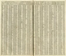
Se: Atlas Major, Bd. 5, Tvl. 43, Stik, exactly taken after that most accurate Survey, persuant to the French Kings Command, by M. Picar and M. de la Hire, Shewing ye great errors of others, By H. Moll ..., and Ukomplet, kun den vestligste del haves
Se: Atlas Major, Bd. 5, Tvl. 44, Stik, exactly taken after that most accurate Survey, persuant to the French Kings Command, by M. Picar and M. de la Hire, Shewing ye great errors of others, and By H. Moll
Se: Frederik den Femtes Atlas, Bd. 7, Tvl. 37, Koloreret kobberstik, Dessiné par J. W. Zollmann Lieut. des Ingen., Accurata Repraesentatio ichnographica Urbis Episcopalis in Ducatu Lotharingiæ dictae Metæ antiquis, and prostat in Offic. Homanniana Norib. A. MDCCXXXIX [1739]. Cum Privilegio
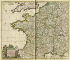
Se: Frederik den Femtes Atlas, Bd. 4, Tvl. 8, divisa tam in Præfecturas generales, quam in Provincias separatas cum regionibus aquisitis, per Fredericum de Wit Amstel., Amstelodami ex Offocina Frederici de Wit cum Privil. D.D. Ord. Holl. et Westfrisiæ, and Skønnet datering ved hjælp af Koeman: Atlantes Neerlandici. - Bd. III, s. 192 og: og P.L. Phillips: A list of geographical atlases in the Library of Congress. - Vol. 1, s. 244
Se: Frederik den Femtes Atlas, Bd. 4, Tvl. 9, divisa tam in Præfecturas generales, quam in Provincias separatas cum regionibus aquisitis, per Fredericum de Wit Amstel., Amstelodami ex Offocina Frederici de Wit cum Privil. D.D. Ord. Holl. et Westfrisiæ, and Skønnet datering ved hjælp af Koeman: Atlantes Neerlandici. - Bd. III, s. 192 og: og P.L. Phillips: A list of geographical atlases in the Library of Congress. - Vol. 1, s. 244
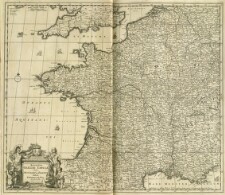
Se: Atlas Major, Bd. 5, Tvl. 27, Konturkoloreret kobberstik, per Fredericum de Wit Amstel., ex Officina I. Covens et C. Mortier, and Skønnet datering ved hjælp af Koeman: Atlantes Neerlandici. - Bd. III, s. 192 og: og P.L. Phillips: A list of geographical atlases in the Library of Congress. - Vol. 1, s. 244
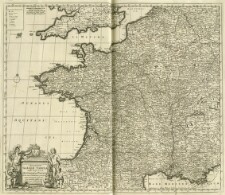
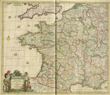
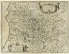
Se: Frederik den Femtes Atlas, Bd. 4, Tvl. 6, Authore Frederico de Wit, Amstelodami ex officina Frederici de Wit in platea vitulina vulgo de Calverstraet sub signo Witte Pascaart, and Skønnet datering ved hjælp af Koeman: Atlantes Neerlandici. - Bd. III, s. 192 og: og P.L. Phillips: A list of geographical atlases in the Library of Congress. - Vol. 1, s. 244
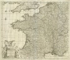
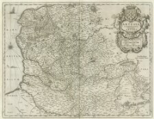
Se: Frederik den Femtes Atlas, Bd. 4, Tvl. 7, Authore Frederico de Wit, Amstelodami ex officina Frederici de Wit in platea vitulina vulgo de Calverstraet sub signo Witte Pascaart, and Skønnet datering ved hjælp af Koeman: Atlantes Neerlandici. - Bd. III, s. 192 og: og P.L. Phillips: A list of geographical atlases in the Library of Congress. - Vol. 1, s. 244
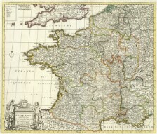
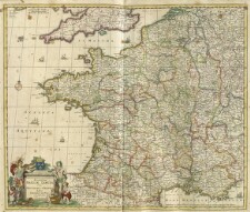
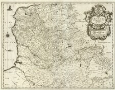
Se: Atlas Major, Bd. 5, Tvl. 25, Konturkoloreret kobberstik, Authore Frederico de Wit, Amstelodami, Amstelodami ex officina Frederici de Wit in platea vitulina vulgo de Calverstraet sub signo Witte Pascaart, and Skønnet datering ved hjælp af Koeman: Atlantes Neerlandici. - Bd. III, s. 192 og: og P.L. Phillips: A list of geographical atlases in the Library of Congress. - Vol. 1, s. 244
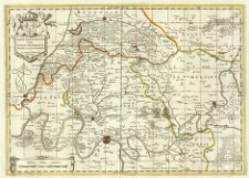
Se: Atlas Major, Bd. 5, Tvl. 26, Kobberstik, Authore Frederico de Wit Amstelodami, Amstelodami ex officina Frederici de Wit in platea vitulina vulgo de Calverstraet sub signo Witte Pascaart, and Skønnet datering ved hjælp af Koeman: Atlantes Neerlandici. - Bd. III, s. 192 og: og P.L. Phillips: A list of geographical atlases in the Library of Congress. - Vol. 1, s. 244
Guillotière, François de la Schenk, Pieter Schenk, Petrus Valk, Gerard
Description:
Se: Atlas Major, Bd. 6, Tvl. 7, Konturkoloreret kobberstik, Fr. Guillo terius Bitur Viu. describ. et CL. V. Petro Pithæo I.C. dedicabat,, and Amstelædami Apud Gerardum Valk et Petrum Schenk
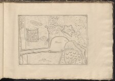
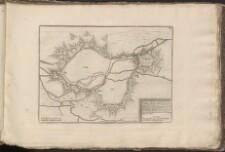
Kobberstik, Kort / Prospekt 56 sidder i: Tables des Forces de l'Europe avec un Introduction a la Fortification, compose de 194 Plans des Villes les plus Considerables du Monde, augmen te de Onze Plans depuis l'année 1720, jusqu'a 1723. Divises selon l'ordre qu'on a juge le plus Convenable / Par N. de Fer, Geographe de sa Majeste Catholique ; A Paris chez I. F. Benar Gendre de l'auteur dans l'Isle du Palais sur le Quay de l'Orlage a la Sphere Royale 1723. - 1 atlas (163 blade med 9 plancher og 146 kortplancher) 31 x 47 cm, Betegnet: Introduction a la fortification dediée a M... le Duc de Bourgogne ... Paris J. F. Benard ..., Tidligere: KBK Ingeniørkorpset Samling XVIII. 10, 12. Indført med titlen: Tables des Forces de l’Europe avec un introduction à la fortification, compose de 194 Plans des Villes les plus considerables du Monde Paris 1723 N. de Fer, Med stempel: Krigsministeriets Bibliothek, and 1100
Se: Frederik den Femtes Atlas, Bd. 4, Tvl. 20, Indhold: Alfabetisk liste over bynavne på kortet, Hører til: Galliæ seu Franciæ Tabula qua omnes procinciæ ... per Nicolaum Visscher. - Frederik den Femtes Atlas, Bd. 4, Tvl. 2 og 10, and Nic. Visser ex. cum Priv.
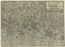
Kobberstik, Paralleltitel: Under Elsas, Autore clariss viro Daniele Specchelio Argetinense, Tekst under kortet: Alsatia quatuor in German ..., and Kortet sidder i: Samling af Kort af forskellige kartografer fra det 16. århundrede]. - 1600?. - Tvl. 27
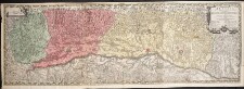
Se: KBK Frederik den Femtes Atlas, Bd. 25, Tvl. 47, Koloreret kobberstik, Kortet er sat sammen af 3 kort, and exhibita per Jaques Michal ... sculpta a Matthæo Seuttero Chalcographo August.
Kobberstik, Kort / Prospekt 16 sidder i: Tables des Forces de l'Europe avec un Introduction a la Fortification, compose de 194 Plans des Villes les plus Considerables du Monde, augmen te de Onze Plans depuis l'année 1720, jusqu'a 1723. Divises selon l'ordre qu'on a juge le plus Convenable / Par N. de Fer, Geographe de sa Majeste Catholique ; A Paris chez I. F. Benar Gendre de l'auteur dans l'Isle du Palais sur le Quay de l'Orlage a la Sphere Royale 1723. - 1 atlas (163 blade med 9 plancher og 146 kortplancher) 31 x 47 cm, Betegnet: Introduction a la fortification dediée a M... le Duc de Bourgogne ... Paris J. F. Benard ..., Tidligere: KBK Ingeniørkorpset Samling XVIII. 10, 12. Indført med titlen: Tables des Forces de l’Europe avec un introduction à la fortification, compose de 194 Plans des Villes les plus considerables du Monde Paris 1723 N. de Fer, Med stempel: Krigsministeriets Bibliothek, and 1100
Janssonius, Joannes Kærius, Petrus Keere, Pieter van den Montanus, Petrus
Description:
Kobberstik, Amstelodami Excudebat Ioannes Ianssonius Anno 1621, and Det trykte kort er indbundet sammen med: La Germanie inferieure de Petrus Keerius c'est a dire Nouvelles et exactes Cartes Geographiques des XVII [17] Provinces Dicelle. - A Petro Montano Amstelodami impensis Pet. Kærii 1622, bagerst
Se: Atlas Major Bd. 62, Tvl. 15, Kobberstik, Antiquitus contenta ... Auscii et Tarbelli ... Bituriges et Arverni ... viæ militares Romanorum ex Tabula Peutingeriana et ex Antonino descriptæ 1703, and Ad intelligentiam ... Lutetiæ Parisiorum apud P.m Moullart-Sanson ... MDCCXXI [= 1721]
Se: Atlas Major, Bd. 8, Tvl. 3, Kobberstik, Per Gerardum Meratorem. Cum Privilegio, Varianttitel: Aqvitania australis regnum Arelatense cum confinijs, and Med tysk tekst på bagsiden
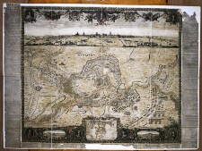
Håndkoloreret kobberstik and Kortet sidder i: Civitates orbis terrarum / Georgius Bruin et Franciscus Hogenbergius. - Coloniae Aprippinae : Godofridum Kempensem, 1577-1588. - Bd. 1, Tvl. 33
Kobberstik, Kort / Prospekt 69 sidder i: Tables des Forces de l'Europe avec un Introduction a la Fortification, compose de 194 Plans des Villes les plus Considerables du Monde, augmen te de Onze Plans depuis l'année 1720, jusqu'a 1723. Divises selon l'ordre qu'on a juge le plus Convenable / Par N. de Fer, Geographe de sa Majeste Catholique ; A Paris chez I. F. Benar Gendre de l'auteur dans l'Isle du Palais sur le Quay de l'Orlage a la Sphere Royale 1723. - 1 atlas (163 blade med 9 plancher og 146 kortplancher) 31 x 47 cm, Betegnet: Introduction a la fortification dediée a M... le Duc de Bourgogne ... Paris J. F. Benard ..., Tidligere: KBK Ingeniørkorpset Samling XVIII. 10, 12. Indført med titlen: Tables des Forces de l’Europe avec un introduction à la fortification, compose de 194 Plans des Villes les plus considerables du Monde Paris 1723 N. de Fer, Med stempel: Krigsministeriets Bibliothek, and 1100